Glenn,VK3YY, and I had swapped a couple of emails during the week about making a SOTA activation or two on Saturday. I spoke with Glenn on Friday and we decided Mt Saint Phillack, VK3/VT-006, would be a good one to try for. The weather during the week had been quite mild, in fact the warmest July on record, and there was no snow being reported at the nearby Mt Saint Gwinear. A few others had recently activated the summit and the walk in is well documented in the Parks Victoria Baw BawNational Park park note.
As a ‘Plan B’ in case of bad weather we had talked about other nearby summits but not really settled on one.
The weather forecast on Friday night was showing isolated snow showers above 900 m and winds at 35 – 55 km/h. I was OK with the isolated snow showers but the thought of strong winds as well didn’t thrill me.
On Saturday morning I checked the BOM site there was a Severe Wind warning for the region with winds around 60 km/h with peak gusts of 90 km/h forecast for elevated parts. There had also been snow falls at nearby Mt Baw Baw overnight meaning there would most probably be snow at Mt Saint Phillack.
Glenn and I exchanged emails early Saturday morning and decided not to go to Mt Saint Phillack but head for Mt Useful, VK3/VT-016, and an unnamed summit VK3/VT-034. Both these summits had roads within 100 m metres of them and had been recently activated.
Glenn and I set off from home about 8:00 am traveling toward Mt Useful via Traralgon and Seaton. From Seaton we headed west along McEvoys Track toward the summit. The maps show that McEvoys Track becomes Springs Rd but all the signs along the road say McEvoys Track.
 |
| Green Hills Link Rd, 2.5 km from Mt Useful |
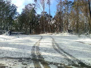
At a guess I’d say it’s about 47 km from Seaton to Mt Useful and we had had traveled about 30 km in, rising to about 850 m ASL, when we saw the first sprinklings of snow. Driving on further we found more and more snow.
About 2.5 km from the summit, at about 1100 m ASL, the road started to become icy and the section ahead of us had more snow than before and was in the shade. The section were we stopped, just north of Growlers Track, was icy underneath and the wind was howling through the burnt trees. The forest from Seton to beyond Mt Useful had been burnt during the January 2013 Gippsland bush fires leaving little foliage on the trees to stop the wind. The temperature outside was two degrees above zero. Glenn and I decided that to drive further without wheel chains or a second vehicle would be too risky and to walk in from here would be no fun at all. In fact it would be plain stupid!
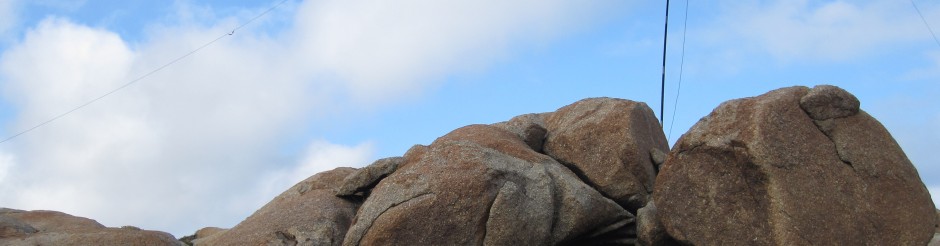
 |
| Access to VK3/VT-034 |
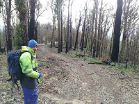
We turned around and headed back down McEvoys Track to Williamsons Spur Track. Turning right here and traveling about 4 km west brought us to an unnamed summit, VK3/VT-034. Parking at the base of the access track that goes up and over the summit we got out and, after donning wind proof pants and jackets, headed back down the road until we were clearly out of the activation zone. Returning past the car and up to the summit the wind was still very strong. Glenn found shelter from the wind a little down the hill and we set up there.
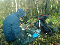
Glenn set his end fed half wave antenna on his squid pole and I hoisted by linked inverted vee antenna into a tree. Glenn was operating on 40 m and I was on 12 m. Glenn made 19 QSOs on 40 m and I got two QSOs on 12 m including Mike, VK6MB for his first ever QSO on 12 m. Borrowing Glenn’s set up I also made 3 quick QSOs on 40m including summit to summit QSOs with Mark VK3UA on Mt Leura, VK3/VS-050 and Allen VK3HRA on Mt Bolton, VK3/VC-023. I could hear Fred VK3SOG calling me on 12 m however he was unable to hear me.
From VK3/VT-034 we looked around for other nearby summits and, seeing VK3/VT-064about 10 km to the east we headed off that way along Glenmaggie Creek Track. A couple of kilometres down the track we found a tree part way across the road and decided to give this summit a miss and head back to Traralgon for fuel.
 |
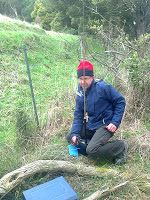
| Glenn at VK3/VT-034 |
After fueling up, and a small detour past a couple of open cut mines, we headed back along the Princes Freeway, turning left at Darnum toward Mt Worth, VK3/VT-066.
With Glenn navigating we arrived at Mt Worth ahead of the impending rain. We stopped a couple of hundred metres past the Mt Worth lookout and then walked back up the road, then scrambled up the road cutting to get into the activation zone. Set up right on the boundary fence Glenn used a Diamond RMH8 loaded telescopic whip directly on top of his FT817 while I set my linked dipole in a tree no more than 2 1/2 metres above the ground. It was so low I that could change the 12 m link without lowering the apex. I gave a few calls on 12 m but got nothing.
 |
| Glenn at Mt Worth |
Glenn was working station on his whip and but the signal reports were not that good. I changed my antenna from 12 m to 40 m and Glenn’s signal increase dramatically. His whip was about 10 cm away from one of the wires in my dipole. When I closed the connection, making my dipole resonate on 7 MHz, his signals got better, when I opened the connection his signals got worse. His vertical whip was obviously coupling into my dipole. RF is an interesting beast at times.
Once Glenn had finished I quickly worked 8 stations on 40 m, with good reports from all despite my low antenna. We then packed up, climbed back down to the road, packed the car and headed home. We were about 15 minutes down the road when it started to rain. It was still raining hard when we got back home.
So even though we didn’t work Mt Saint Phillack, or Mt Useful, we still activated two summits, scored eight activator points, worked two S2S contacts and I got another two QSOs for the 12 metre challenge.
73


One Response to Two and a half SOTA summits on a Saturday